


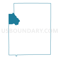
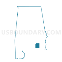
Pine Level, Coffee County, Alabama
About
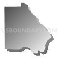
Outline

Summary
| Unique Area Identifier | 521460 |
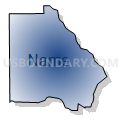
| Name | Pine Level |
| County | Coffee County |
| State | Alabama |
| Area (square miles) | 29.20 |
| Land Area (square miles) | 28.99 |
| Water Area (square miles) | 0.21 |
| % of Land Area | 99.28 |
| % of Water Area | 0.72 |
| Latitude of the Internal Point | 31.48776630 |
| Longtitude of the Internal Point | -86.16434050 |
Maps

Graphs
Select a template below for downloading or customizing gragh for Pine Level, Coffee County, Alabama


Neighbors
Neighoring Voting District (by Name) Neighboring Voting District on the Map
- Danley's Cross Roads, Coffee County, AL
- Elba National Guard Armory, Coffee County, AL
- Lee Community, Coffee County, AL
- Newbia, Coffee County, AL
- Weeds Store, Crenshaw County, AL
Top 10 Neighboring County Subdivision (by Population) Neighboring County Subdivision on the Map
- Elba CCD, Coffee County, AL (6,710)
- Brantley CCD, Crenshaw County, AL (3,089)
- Jack CCD, Coffee County, AL (2,057)
Top 10 Neighboring Unified School District (by Population) Neighboring Unified School District on the Map
- Coffee County School District, AL (18,627)
- Crenshaw County School District, AL (13,906)
- Elba City School District, AL (5,178)
Top 10 Neighboring State Legislative District Lower Chamber (by Population) Neighboring State Legislative District Lower Chamber on the Map
Top 10 Neighboring State Legislative District Upper Chamber (by Population) Neighboring State Legislative District Upper Chamber on the Map
Top 10 Neighboring 111th Congressional District (by Population) Neighboring 111th Congressional District on the Map
Top 10 Neighboring Census Tract (by Population) Neighboring Census Tract on the Map
- Census Tract 105, Coffee County, AL (4,558)
- Census Tract 101, Coffee County, AL (2,057)
- Census Tract 9639, Crenshaw County, AL (1,408)